
Platform
app.pan-optic.net

Real-time 3D site model with progress layers, volume calculations, and deviation highlighting — all in a browser, nothing to install.
How It Works
01
A drone photographs the site to create an accurate, up-to-date 3D copy.
02
The platform merges imagery with project documentation and the BIM model.
03
Physical volumes, work planning and progress assessment — with full survey history.
Workflow
Plan on real ground
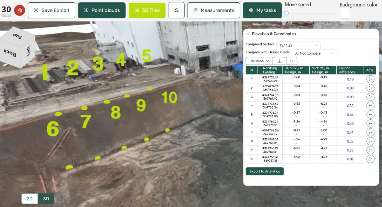
Use live drone data instead of guesswork to plan cut and fill volumes, map the soil mass, and record precise elevations and coordinates before earthworks begins.
→ Cut & Fill Balance
→ Soil Mass Map
→ Elevations & Coordinates

Control without site visits
Review immersive 360° panoramas, assess the scope of work performed, and track running totals — all without leaving your desk.
→ 360° Panoramas
→ Scope of Work Performed
→ Counter
Resolve disputes with evidence
Compare survey layers over time, apply precision measuring tools, and attach notes with location context to pin down exactly what changed and when.
→ Layers
→ Measuring Tools
→ Notes


Hand over with a record
Build a complete, timestamped record of the site from day one. Organise all surveys in the central archive, follow the shooting schedule, and share annotated screens for sign-off.
→ Central Archive
→ Shooting Schedule
→ Shared Screens & Comments
Measurable Impact
Typical projects lose 5–15% of budget to rework and slip 1–2 months on schedule. Continuous aerial control claws much of that back.
33–53%
less rework
40–60%
fewer penalties & fines
40%+
lower incident losses
Reference values relative to typical project losses.
In the Field
Software designed around what actually happens on an active construction site, not a demo environment.

Aerial survey of an active site

Earthworks and groundworks

Structural progress over time
Why Panoptic
I
No infrastructure to deploy. No specialist hardware to procure. Connect, configure your first project, and your team is surveying within days of signing.
II
Survey data, 3D models, and project records can live on your own servers. On-premise deployment available — we never need to touch your data unless you want us to.
III
Take a platform licence and run it yourself, fly with your own drones and send us the data, or let us handle everything end-to-end. Scale your engagement as the project demands.
Engagement Model
Tier 01
Deploy Panoptic on your own infrastructure or in the cloud. Your team flies the drone and processes data through the platform — we provide software, documentation, and onboarding support.
Request pricing
Tier 02
Use your own drone operators. Capture the site and send us the raw imagery. We process, model, and deliver the analysis back to your platform project within 24 hours.
Request pricing
Tier 03
Everything managed end-to-end. We schedule and run the flights, process the data, and deliver regular reports with your project team. You review the results, we handle the rest.
Request pricing
FAQ
What do we need to get started?
+
Do we need to install anything on site?
+
Can it run inside our own infrastructure?
+
Who flies the drone?
+
What does each survey give us?
+
Does it work with our BIM model and drawings?
+
Contact
We typically respond within one business day. For urgent matters, call us directly.
info@pan-optic.net
Phone
+32 466 07 82 53
Address
Haachtsesteenweg 582 box 3
1910 Kampenhout, Belgium